The first time I did the Grapeyard Ridge Trail was several years ago during the early spring season. My uncle and I had begun on the Roaring Fork Motor Nature Trail where the Jim Bales barns and cabins are and headed east. The trek is full of little ups and downs, but nothing terribly difficult. At various points one may become disoriented by the occasional unmarked side trail. I remember guessing at a few, luckily they had all worked out. When we arrived at Campsite #32 about 4.5 miles in, we stopped for a lunch break. Without bothering to look at my map to see that we needed to retrace our steps back to a junction and uphill, we elected to follow an obvious, wide, and well trodden path from below the campsite and downhill. It followed the creek and as I said, came across as your typical Smokies trail. There were spots where we even crossed Injun Creek on footlogs. I had remembered reading about a wrecked boiler in the creek, but we never saw one, so then we started to second guess our direction of travel. Rather than turn around, we kept following the obvious path, eventually coming out beside the ranger station in Greenbrier. It was then determined that we went in the opposite direction we needed to from Campsite #32; thus, reaching our hikes end a few miles north of where we originally planned to be. Luckily, the distance covered was shorter and we were able to reach the road before our shuttle had arrived and wave them down. When I got back to Michigan, I did some research and discovered that the path we ended up taking was in fact the Injun Creek manway, popular among locals. So no harm done, just a part of the Grapeyard Ridge Trail left unfinished.
With that said, the portion I still needed to complete was the eastern 3.2 miles coming out of Greenbrier. I had numerous opportunities to do it throughout the year, but I figured I would save it for a morning hike on a day I had to go back up Mt. LeConte. This mid-September day was warm and sunny, and surprisingly there were a lot of cars parked at the trailhead. I wondered if I might see anyone, but apparently they were there for the other trails in the area or playing in the river. Right away the trail moves uphill, passing faint side paths along the way, representative of the western half of this trail. I had to step over a few small blowdowns, but nothing major. There were several small creek crossings. Fortunately water levels were down, but I can see them being pesky after a rain. And there wasn't much happening in terms of wildflowers, but there were patches of goldenrods, asters, daisies, sweet-joe pye-weed, and some unidentified fruit. The ascending wasn't all too bad until I began to approach James Gap. At this point I was beginning to feel the sun's warmth and the climb steepened. I was relieved to reach the gap because I knew it meant that I was nearing the wrecked boiler, and just beyond that, the campsite. So down I went, evntually picking up the creek. Sure enough as I rounded the bend along the creek, there to my right was the scattered wreckage of an old, rusted logging boiler. Most of the pieces were left intact, just strewn along the creek bed. The wheels were being overgrown with wildflowers like pink and white turtlheads.
With that said, the portion I still needed to complete was the eastern 3.2 miles coming out of Greenbrier. I had numerous opportunities to do it throughout the year, but I figured I would save it for a morning hike on a day I had to go back up Mt. LeConte. This mid-September day was warm and sunny, and surprisingly there were a lot of cars parked at the trailhead. I wondered if I might see anyone, but apparently they were there for the other trails in the area or playing in the river. Right away the trail moves uphill, passing faint side paths along the way, representative of the western half of this trail. I had to step over a few small blowdowns, but nothing major. There were several small creek crossings. Fortunately water levels were down, but I can see them being pesky after a rain. And there wasn't much happening in terms of wildflowers, but there were patches of goldenrods, asters, daisies, sweet-joe pye-weed, and some unidentified fruit. The ascending wasn't all too bad until I began to approach James Gap. At this point I was beginning to feel the sun's warmth and the climb steepened. I was relieved to reach the gap because I knew it meant that I was nearing the wrecked boiler, and just beyond that, the campsite. So down I went, evntually picking up the creek. Sure enough as I rounded the bend along the creek, there to my right was the scattered wreckage of an old, rusted logging boiler. Most of the pieces were left intact, just strewn along the creek bed. The wheels were being overgrown with wildflowers like pink and white turtlheads.
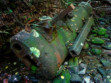
I took some various pictures of the wreckage, then moved in closer for inspection. To my amazement, I read on the side of the boiler the manufacturer "Nichols & Shepard Co." based out of Battle Creek, MI. Now there's a shout-out back to the Mitt! It was so surreal to see something like that in the park, not to mention that I had been putting this hike off for a few years since that spring debacle. Continuing downhill, I soon reached the infamous junction, which now had a sign. If only it was there a few years ago. Moving on, I paid a quick visit to the campsite, which was being occupied by some overnighters. I didn't linger and chose to head on back, for I still had an entire afternoon of climbing left to do.
 RSS Feed
