Last week saw me scrap two hikes that threw off my goals in terms of miles, so I had to totally revamp my scheduled hikes for the rest of the year. I'm glad I did, though, because I was able to condense some trips to the same place into one hike. In some cases it meant more long hikes, especially those above 19 miles long, and even some steeper ones that involve 4,000+ feet in elevation change. But it also means I can achieve my goal of reaching 600+ miles out of the park's 900 this year should I stick to my guns. With that said, I decided to give the Fork Ridge Trail another this week.
I figured this trail would be overrun with summer growth because it isn't popular by any means, despite its accessibility from Clingmans Dome Road. But it did garner some attention this past week when a bear tore open the roof of a convertible parked at the trailhead. When Bonnie and I drove up the dome road last week we saw a park vehicle there the morning it happened, but had no idea at the time that such an event occurred. So maybe my delay in hiking down Fork Ridge for a week turned out to be a good thing!
With the oppressive heat still roasting the lowest elevations, it's probably wiser to do upper elevation hikes this time of year, and Fork Ridge fits that description. It is also the last hike I need to do to have completed every trail that emanates from the dome road. I had plenty of incentive to knock it out, despite the potentially unfavorable trail conditions. The weather forecast called for a chance of storms in the afternoon, so I hit the trail early with hopes of being done and back in town by lunchtime.
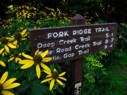
Skies were mostly clear on the drive up with the occasional cloud getting hung up on the highest ridges. The trailhead and sign for Fork Ridge was completely covered by coneflower and filmy angelica, so it took a couple seconds to find the path. It was obvious from the start that if the trail was overgrown here, it wouldn't be any better the rest of the way down. Unfortunately, my projection was correct.
I figured this trail would be overrun with summer growth because it isn't popular by any means, despite its accessibility from Clingmans Dome Road. But it did garner some attention this past week when a bear tore open the roof of a convertible parked at the trailhead. When Bonnie and I drove up the dome road last week we saw a park vehicle there the morning it happened, but had no idea at the time that such an event occurred. So maybe my delay in hiking down Fork Ridge for a week turned out to be a good thing!
With the oppressive heat still roasting the lowest elevations, it's probably wiser to do upper elevation hikes this time of year, and Fork Ridge fits that description. It is also the last hike I need to do to have completed every trail that emanates from the dome road. I had plenty of incentive to knock it out, despite the potentially unfavorable trail conditions. The weather forecast called for a chance of storms in the afternoon, so I hit the trail early with hopes of being done and back in town by lunchtime.
Skies were mostly clear on the drive up with the occasional cloud getting hung up on the highest ridges. The trailhead and sign for Fork Ridge was completely covered by coneflower and filmy angelica, so it took a couple seconds to find the path. It was obvious from the start that if the trail was overgrown here, it wouldn't be any better the rest of the way down. Unfortunately, my projection was correct.
Immediately I was already having to fight off nettles and briers, wiping off spiderwebs, and scaling downed trees. I tried to admire the changing environment as much as I could despite the distractions. Early on, the trail passed through a fir and fern forest, combined with the morning light passing through the trees making for a pleasant scene. About a mile out, the last sounds of traffic from the dome road faded from existence, leaving me to only the trail...and the spiderwebs. Seriously, they were everywhere, from tree to tree and at all heights. There frequency and abundance was appalling and annoying. I was so sick of constantly having to shed them that I went with holding branches for a few miles to try catch them before they'd get strung across my face. Sometimes the plan worked, while other times I swear the webs found ways to dodge the branches and still find my face. To say I broke through a thousand webs in all would be the truth. And when I didn't have to deal with webs, I had to navigate blowdowns that continually slowed my progress. And when there weren't blowdowns, I was getting hacked by the thorns and teeth of nettles and briers. My arms and legs were covered in red railroad tracks by days end, all itchy and burning. Still, I tried to enjoy myself as much as I could. I took note of not only the wildflowers but the plethora of different mushrooms growing along the trail. They were in all sorts of shapes, colors, and sizes the whole way down.
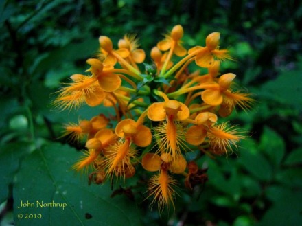
Wildflowers that were common much of the way down were the coneflower, white snakeroot, erect goldenrod, white wood asters, filmy angelica, wide leaved sunflowers, and hawkweed. Some wildflower firsts for the year included the miniature, blue southern harebells and Canada goldenrod. Like the spring beauties and trout lilies of spring, the southern harebells and hawkweed almost always appeared together. There were some yellow gerardia still lingering while most of the yellow fringed orchids had turned sour. As soon as I saw the orchids, I hoped I could find at least one in full bloom for I was yet to see one in such fashion. On previous hikes they were all budding and here they were fading. Finally I caught one beside the trail in decent shape and took time to enjoy its presence.
Wildflowers that were common much of the way down were the coneflower, white snakeroot, erect goldenrod, white wood asters, filmy angelica, wide leaved sunflowers, and hawkweed. Some wildflower firsts for the year included the miniature, blue southern harebells and Canada goldenrod. Like the spring beauties and trout lilies of spring, the southern harebells and hawkweed almost always appeared together. There were some yellow gerardia still lingering while most of the yellow fringed orchids had turned sour. As soon as I saw the orchids, I hoped I could find at least one in full bloom for I was yet to see one in such fashion. On previous hikes they were all budding and here they were fading. Finally I caught one beside the trail in decent shape and took time to enjoy its presence.
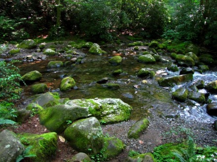
The second half of the trail wasn't much different than the first. Same grade of descent, several blowdowns, tons of mushrooms, more teething nettles and briers, wildflowers in bloom, overwhelming spiderwebs. At times I could get glimpses through the trees of the Noland Divide towering to the west, but views were otherwise hard to come by this day. After the trail hooks around the ridgeline for the last half mile, it plummets into the woods toward the river valley and a sea of nettles. I knew I was close as the sounds of the flowing Deep Creek got louder.
When I came to the shores of the river, there was no bridge crossing to be seen. The first time I passed by on the other side during my Deep Creek hike I didn't see one then either. Well, I like going away from hikes knowing that I saw and did everything I could, hiking every mile, every tenth, every foot of each trail. This meant crossing the creek and reaching the trail's terminus at the junction with the next trail. I found a decent rock hop to my right and determined it to be the best way across. Every rock was slick, it didn't matter the size, so paying close attention to footing was essential. Some rocks were close, others farther apart, and all were surrounded by deep pools of water, so one slip and it was a wet rest of the morning. Patience was the key as it took me at least five minutes to get across. At times I would double back a few rocks to get the right foot placement for future steps. I even squatted a couple of times to assure my balance or use my hands to grip a rock as I stretched out a leg. The distance between one rock and the next might have been a couple inches, but the time between each step felt like an eternity even then. My last step to reach the shore was the riskiest, for the rock face was angled and slick with no spot for the boot to catch and expect to stand. It meant that I had to make long strides and hot foot it to the shore speedily, even over some deep pools. After another squat, a few deep breaths, and envisioning my path several times in my head, I went for it..................SUCCESS!!!
It was a great feeling to look back in amazement that I was able to cross the stream unscathed, but my joy quickly faded when the obvious struck me...I would have to recross in order to get back. But first, I needed to reach the intersection with the Deep Creek Trail, finish the trail, and say hello to some backpackers at the nearby campsite. They were curious about my trek down, and I didn't shy away from telling them to find another way out. They appreciated my advice, but too bad I couldn't follow it. In attempt number two, I chose to take a different way across the creek. But this time I came prepared, strategically chucking rocks from shore to create a more suitable path across. It allowed for better footing and eased the tension in places that otherwise would have been very risky. There were still places that required second and third looks for me to feel sure about what I was doing. I managed to make it across without a hitch, instantly putting my hands on my knees and chuckling when I touched solid ground. The water was finally behind me, only nettles, briers, and blowdowns standing in my way.
After recrossing the creek for the second time, I took a break for a snack and water to refuel for the wonderful trek up. I also chose to pack my camera away because I had seen everything I needed to see on the way. Similar to my hike through the traveshamockery of a trail called Deep Creek, my focus on the ascent was to waste no time and battle through, over, and under all that stood in my way. The good thing about doubling back on a rarely used trail is that all the spiderwebs are broken, so that's one less annoyance to deal with. One also has the advantage of knowing what to expect when it comes to the overgrown places and how to traverse the blowdowns. Like a hiker possessed, I blazed through the nettles, briers, wildflowers, trunks, and branches without hesitation. If I recall, it took me two hours getting down with all the fidgeting and picture taking. The push up was a different story, seeing my return take an hour and forty minutes.
As frustrating as such a hike can be, I still came away with a feeling of satisfaction. For one, I was glad to have it all behind me, another section of the map filled in. But a trip like that can also be adventurous and unforgettable. Should I choose to hike Fork Ridge in the future, at least I now know for sure NOT to do so in the summer...or wait til the park service decides to rip through there with saws and axes.
As frustrating as such a hike can be, I still came away with a feeling of satisfaction. For one, I was glad to have it all behind me, another section of the map filled in. But a trip like that can also be adventurous and unforgettable. Should I choose to hike Fork Ridge in the future, at least I now know for sure NOT to do so in the summer...or wait til the park service decides to rip through there with saws and axes.
 RSS Feed
